Article and photos by Lois Mano
There are many things to enjoy about this hike, not the least of which is its charming name: Zuni-Acoma…or Acoma-Zuni. Depending on whether you hike east from the trailhead at Highway 53 (the direction that begins closest to Zuni Pueblo) or west from Highway 117 (the trailhead that is closest to Acoma Pueblo), the signage is named in a different order.
This trail connecting the two pueblos has been used as a footpath for countless centuries, so there is a deep feeling of connection to time and history when hiking in the footprints of the ancient Puebloans. It’s not unusual to encounter pottery sherds and other lithic scatter on the edges of the lava field. Of course, any artifact found on federal land is protected by law and must be left where you found it.
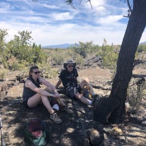
On Memorial Day weekend, our crew decided to through-hike the trail from east to west, so we were officially hiking the Acoma-Zuni Trail. After shuttling cars the approximately 30-minute drive from one end to the other, we began hiking around 10:30 am on a clear, windless morning.
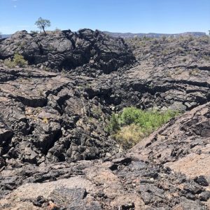
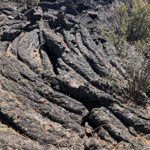
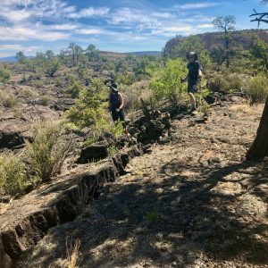
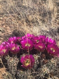
Though not in an official wilderness area, the heart of the lava field feels absolutely remote and wild. The trail crosses some of the roughest, toughest, boot-eating terrain you will ever encounter: jagged plates and mounds of black ropy pahoehoe lava left behind by multiple eruptions, some as recently as 3,000 years ago. That’s like…yesterday, in geologic time. There is vegetation growing out of what appears to be solid rock, including cacti, gorgeous pygmy pine forests, and ferns populating rocky fissures. The lava field is edged by sandy grassland; the trail has a surprising amount of diversity along its approximately 8.6-mile length. I say approximately because we tracked our route with a GPS unit, and that was what it read at the end, which is not in agreement with the 7.5-mile distance described on the NPS website. We did not deviate from the marked trail, so it’s unclear why there is a mile of discrepancy. If you don’t want to dedicate an entire day, you can do a shorter out-and-back hike and still get a great taste of the area.
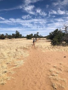
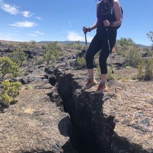
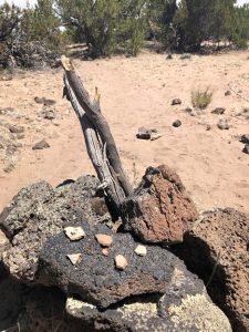
Speaking of marked trail, one of the tricky bits about hiking the Acoma-Zuni Trail is that you navigate guided by stacked stone cairns, many of which are embellished with tall sticks. They tend to blend into the surrounding terrain, so you need to keep an eye peeled as you move from cairn to cairn. Fortunately, they are well positioned and line-of-sight, for the most part. This is a trail where cairns serve their true purpose: for navigation. It’s critical that you not disturb existing cairns or add your own. People could get lost and die out there. No joke.
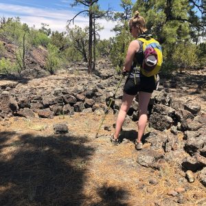
The lava beds are fierce; the black rock radiates any heat, making it hotter than you might expect by looking at the weather forecast. We were hiking on a day when the high was supposed to be 85, but it definitely felt like about 90 on the lava. Shade is sparse, though there are some pine thickets that are tall enough to provide a respite from the sun. Still, this is not a place to be in midsummer, nor is it a good idea to be out on the lava if thunderstorms are forecast: basalt (lava) contains large amounts of iron, and actually conducts electricity. In some spots, you could be the tallest thing around. This is not a good combination on a stormy day.
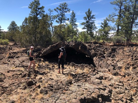
A deceptive aspect of the lava field is that it appears fairly uniform when viewed from the edge, but the trail is constantly going up and down the undulating surface. Fissures split the ground everywhere, some of which you must hop across. Depressions caused by ancient collapses of chambers beneath the lava often contain the entrances to lava tube caves, another fantastic feature of the park and worth exploring (with care, the proper gear, and someone with caving experience as a guide).
Another thing to notice is the quiet surrounding you in the center of the lava field: the acoustic effect of so much texture results in a dampening of sound not unlike the quiet of a snowy day. The hike took our group of fairly fit folk about 6 hours, with lunch and a few rest breaks. By the time we reached the western edge of the lava field and crossed the final bit of sand, we all had sore feet from the unforgiving rough rock. Each of us drank about 3 liters of water, which I would consider the minimum per person one should have on this hike. It was a spectacular day. There is something special about knowing you have fully committed to traveling across terrain like this, which is why I enjoy doing it as a through-hike. Hopefully this report will inspire you to give it a try; the Zuni-Acoma/Acoma-Zuni Trail truly is one of the most unique experiences New Mexico has to offer.
Learn more about the El Malpais National Monument.